Anyone inclined to brave the tourists and goobers up near Ponca Sat? I will have to do a day trip and be at church Sunday. I haven't done the Ponca run in years.
Shout up any less crowded but interesting floats you may be interested in... at least I would guess it will be crowded. Closer to Clinton the better.
Archey at Clinton
Archey at Clinton
Last edited by Clif on Sat Apr 11, 2009 6:32 am, edited 1 time in total.
You sure this is on the right channel?
-
Shark Attack

- ....

- Posts: 443
- Joined: Fri Aug 19, 2005 5:09 pm
- Location: Round Mountain, AR
Re: Buffy Sat or other family friendly
Sounds good to me. Of course I'll have to bring the Jr. paddler too 
Wes
Wes
Wes
Re: Buffy Sat or other family friendly
Are you talking Ponca to Kyles? Gary and I might be interested if it rains more and the level is up. According to what is running that day as to where we will decide to go.
Karla
Karla
Re: Buffy Sat or other family friendly
Karla, Karla, 'scuse me for a moment.... well DUH..... 
Of course in April almost all plans in Arkansas are dependent on if and how much rain falls. We don't discuss such conditions. If none.. it will prolly drop too low. If too much, well ya go somewhere else, If too cold, my little one may not be a good idea. Both guys may be with me. We should get a good idea of conditions on Friday.
Of course in April almost all plans in Arkansas are dependent on if and how much rain falls. We don't discuss such conditions. If none.. it will prolly drop too low. If too much, well ya go somewhere else, If too cold, my little one may not be a good idea. Both guys may be with me. We should get a good idea of conditions on Friday.
You sure this is on the right channel?
-
Shark Attack
- ....
- Posts: 443
- Joined: Fri Aug 19, 2005 5:09 pm
- Location: Round Mountain, AR
Re: Buffy Sat or other family friendly
Level came up good.. did not drop very much either so today is at the top end of ample water. Should be well above 2.5.
BUT forecast temps are going down. What yall think?
Another option might be 4 miles of Archey Fork.. ending in Clinton city park.
You sure this is on the right channel?
-
Shark Attack
- ....
- Posts: 443
- Joined: Fri Aug 19, 2005 5:09 pm
- Location: Round Mountain, AR
Re: Buffy Sat or other family friendly
Hows about meet at Grinder's Ferry at 10:30 & float down to Gilbert. That will let it warm up a little bit for the kids & not such a long & cranky ride home.
Wes
Wes
Wes
-
Shark Attack
- ....
- Posts: 443
- Joined: Fri Aug 19, 2005 5:09 pm
- Location: Round Mountain, AR
Re: Buffy Sat or other family friendly
Clif, I just talked to Lance & he would rather paddle something other than the Buffalo. So the Archey Fork trip sounds good. If you want to float Archy post when & where & what time. (plans) I won't be able to reply so just post.
Wes
five o one 730 two two 7 one
Wes
five o one 730 two two 7 one
Wes
Re: Buffy Sat or other family friendly
I was gonna check it this afternoon. Did not.. got busy working.
It should be ok. We can meet at the park in Clinton, right off the hiway take road between subway and huddle house. Parking lot close to river at ball courts. Same 10:30 or so?
I may drive up and check it. I will call. I am five 01 47 two nineteen 85
Level was good Fri pm.. hoping it will work today. Meeting at and doing about 4 miles ending at Clinton city park off of hwy 65. Holler at one of us if ya wanna join in.
You sure this is on the right channel?
Re: Archey at Clinton
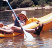
Wow! what a day on the river. I was told this was a class I+. Maybe with a foot more of water. We had to do some for sure turns and rock dodging at the level it was today in the buffy barge. Then Lance would run right over the rocks on purpose in his creek boat.
Blue skies, all kinds of budding trees, dogwood blooms, the purple crabrooster trees... saw ducks, a hawk, a swimming deer...
Thanks guys
Blue skies, all kinds of budding trees, dogwood blooms, the purple crabrooster trees...
Thanks guys
You sure this is on the right channel?
-
Cowper

- .....

- Posts: 2423
- Joined: Sun Jul 10, 2005 10:39 am
- Name: Cowper C
- Location: Conway, AR
- Contact:
Re: Archey at Clinton
Clif,
Would you mind posting the GPS coordinates of the place you put in?
I think the Archey Fork is a beautiful stream that is little known due to limited access points, kind of like South Fork Little Red until we nosed around in the Gulf Mountain WMA and made friends with the land owners at the Low Gap bridge.
I've just recently learned that AG&FC owns 80 acres that touches the river at N35 40.963' W92 34.180'
I've been meaning to drive up there sometime and see if there is public road access to this end of the property. If you know anything about that, please share that as well!
Trash: Get a little every time you go!
-
Cowper
- .....
- Posts: 2423
- Joined: Sun Jul 10, 2005 10:39 am
- Name: Cowper C
- Location: Conway, AR
- Contact:
Re: Archey at Clinton
Clif,
Would you mind posting the GPS coordinates of the place you put in?
I think the Archey Fork is a beautiful stream that is little known due to limited access points, kind of like South Fork Little Red until we nosed around in the Gulf Mountain WMA and made friends with the land owners at the Low Gap bridge.
I've just recently learned that AG&FC owns 80 acres that touches the river at N35 40.963' W92 34.180'
I've been meaning to drive up there sometime and see if there is public road access to this end of the property. If you know anything about that, please share that as well!
Would you mind posting the GPS coordinates of the place you put in?
I think the Archey Fork is a beautiful stream that is little known due to limited access points, kind of like South Fork Little Red until we nosed around in the Gulf Mountain WMA and made friends with the land owners at the Low Gap bridge.
I've just recently learned that AG&FC owns 80 acres that touches the river at N35 40.963' W92 34.180'
I've been meaning to drive up there sometime and see if there is public road access to this end of the property. If you know anything about that, please share that as well!
Trash: Get a little every time you go!
Re: Archey at Clinton
Well..
1 There are two (2) places that trees block the main channel. One we had to portage. Easily visible as you come to it. Plenty of room to cross the rocks on the inside of the curve thru the strainers. Tree 2 would be of no consequence with 6" more water. An alternate route over the shoal instead of down main channel was there, but we left lots of plastic, kinda shallow. This tree was actually a huge one that looks to be there a while that could easily be ducked under. A 5 or 6 inch smaller tree in front of it was the main obstacle as a zig zag around both was more than we wanted to try and maneuver. But again this blockage was easily visible as one approached.
2 I did a good ole boy level guess. With no gauge on this piece of river it is tricky. I was told if it looks like a good level from the 65 bridge, it should be.. and was. From some hiking to a couple of sections, I had guessed if it was close to the tire swing, it would be good. There is a mark on the bridge, but I did not notice it yesterday. I can guestimate this real close. A more accurate judge of this river may be the "just over the hill to the north" middle fork little red. All depends on how the weather comes thru.
The road we used goes down thru LOTS of purple marked leased out paper company land. Yet does appear to be public access. I did not mark with my gps.. no topos in it. I can guess real close with the topo program I have. I do have the turnoff hwy 16 coords. The area you mention looks to be upstream. Perhaps it could take out here.
You sure this is on the right channel?
-
Shark Attack
- ....
- Posts: 443
- Joined: Fri Aug 19, 2005 5:09 pm
- Location: Round Mountain, AR
Re: Archey at Clinton
That stretch was a hoot. Much more action than I had planned. The action was busy for the whole trip. No carnage, just a few very wide eyes. :shock: I had never been down this creek before so I was depending on Clif to lead the way....well we both learned a few things.
First trip in a new boat. The Remix 10 is very more capable than I am. I pinballed down a rock garden & was very stable even when getting T-boned by Clif's canoe.
Wes
First trip in a new boat. The Remix 10 is very more capable than I am. I pinballed down a rock garden & was very stable even when getting T-boned by Clif's canoe.
Wes
Wes
Re: Archey at Clinton
Wes! Man.. ratting me out or what??Shark Attack wrote: even when getting T-boned by Clif's canoe.
Yep learned a few things... like stay behind Clif. Can I make a poke at myself?
You sure this is on the right channel?
Social Media
Who is online
Users browsing this forum: Amazon [Bot] and 1 guest